Reading the Evidence · Case retrial
Proctor’s Ledge: Perley Put Salem’s Hangings There in 1921
Hoax and Hindsight Published
In 1921, Sidney Perley put Salem's 1692 hangings on what is now Proctor's Ledge, below the summit of Gallows Hill. A research team confirmed his answer in 2016, but no archaeological excavation has been reported there, so the ledge is the most likely site by current evidence rather than a proven one.
Docket
- Case
- The Salem execution site, 1692
- Years
- 1692 hangings; Perley's study 1921; Gallows Hill Project 2016
- Place
- Proctor's Ledge, below the summit of Gallows Hill, Salem, Massachusetts
- The claim
- That the 1692 hangings took place on the summit of Gallows Hill
- The verdict
- Research consensus as of 2026: Proctor's Ledge, the lower ledge below the summit, as argued by Sidney Perley (1921) and confirmed by the Gallows Hill Project (2016); no archaeological excavation reported
- Hinges on
- Perley's land records and family traditions, Rebecca Eames's answer of August 19, 1692 that she was at the house below the hill, and what can be seen from Boston Street
- Status
- As of current evidence
Salem hanged nineteen people on four days, from June 10 to September 22, 1692, after the Salem witch trials that condemned them. Giles Corey died by the court's action too, but he was not hanged: he was pressed to death, on September 19 by Samuel Sewall's diary or September 16 by Robert Calef's account (Exhibit D and Exhibit B), as set out in the case of Giles Corey, pressed rather than hanged in the same year.
No paper from 1692 read for this page names the spot where the nineteen died. The question here is where the evidence puts it, and how firmly.
Order of proceedings 6 parts
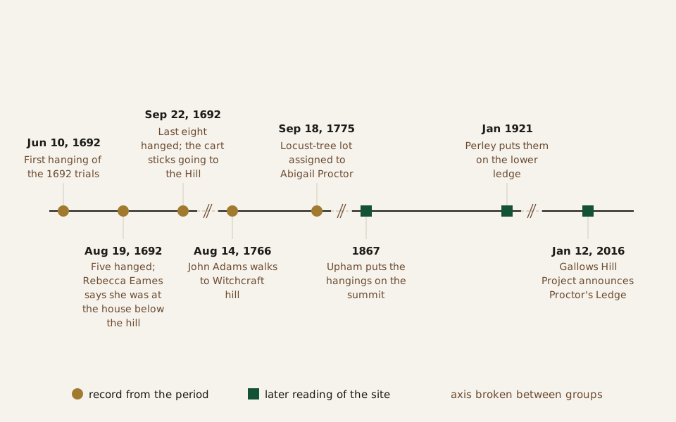
Diagram: Hoax and Hindsight · CC BY 4.0
Credit line to copy
"The Salem execution site, 1692 to 2016" by Hoax and Hindsight, licensed under CC BY 4.0 (https://creativecommons.org/licenses/by/4.0/). Original: https://hoaxandhindsight.com/archaeology-retested/proctors-ledge/
Data: W. Elliot Woodward, Records of Salem Witchcraft, vol. 2 (1864), p. 146; Diary of Samuel Sewall, vol. 1 (1878), p. 363; Robert Calef, More Wonders of the Invisible World (1700), ed. Samuel G. Drake (1866), vol. 3, p. 45; Charles W. Upham, Salem Witchcraft (1867), vol. 2, pp. 376-379; Sidney Perley, Essex Institute Historical Collections 57 (1921), pp. 1-17; Salem State University news release, January 12, 2016
From the hanging of June 10, 1692, to the 2016 announcement: circles mark records from 1692 to 1775, squares mark later readings of the site. The axis is broken between groups. Drawn from the table published with this page (Exhibits A, B, D, E, F and G).
The dated events, 1692 to 2016, with sources (CSV) (where the data comes from) Data: Woodward (1864); Sewall (1878); Calef (1700), ed. Drake (1866); Upham (1867); Perley (1921); Salem State University (2016)
Where did the old story put the gallows?
The 1692 accounts read here point only at “the Hill.” Calef, a Boston merchant who wrote against the trials, says the cart carrying eight people to execution on September 22 was “going to the Hill” when it stuck (Exhibit B). In his 1866 edition, Samuel G. Drake added a note that “The Hill” “has ever since been pointed out as Witch Hill, or more generally Gallows Hill.”
Charles Upham's history of 1867 chose a spot on that hill. He described a bare cliff on the western side of Salem and wrote, “At the top of this cliff, on the southern brow of the eminence, the executions are supposed to have taken place” (Exhibit E). He suggested the town chose the highest point to defy the Devil in his own realm, the air.
Upham was candid about his footing. “There is no contemporaneous nor immediately subsequent record,” he wrote, “that the executions took place on the spot assigned by tradition.” His support was a letter of 1791 reporting that a man born in 1692 had heard from his mother's nurse that she saw the condemned “hanging on Gallows' Hill” from a chamber window.
Perley later took that letter apart (Exhibit F, p. 8). The house where the man died was not built until 1730, so it could not be where he was born. He was born on May 22, 1692, Perley added, so the only hanging the nurse could have seen in those weeks was Bridget Bishop's, on June 10.
“Gallows Hill, Salem, where the witches were hung.” · Unknown author · Public domain
Full credit
"Gallows Hill, Salem, where the witches were hung." by Unknown author — https://commons.wikimedia.org/wiki/File:Gallows_Hill,_Salem,_where_the_witches_were_hung._-_DPLA_-_64eb4c9dba10556ef5bc3647d684749c.jpg — Public domain (anonymous mounted photograph dated by the cataloguer between 1895 and 1905. US: if published, before 1931; if never published, an anonymous unpublished work is protected 120 years from creation, which ended at the latest at the end of 2025; the Boston Public Library marks it No Copyright - United States. EU: anonymous work, more than 70 years since it was made and since any publication. Risk noted: no publication record was checked, and the photographer is not known.); modified: card and share image only: cropped by the site build inside the photograph's mount; the article page shows the whole mount uncropped
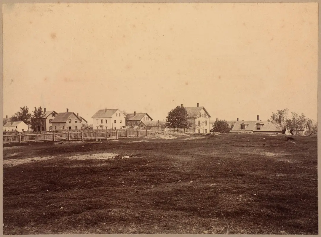
Gallows Hill, Salem, where the witches were hung: the title this photograph carries in the Boston Public Library's catalogue, dated between 1895 and 1905. It is a title from around 1900; this page sets out where the evidence now places the hangings, and the photograph does not show which part of the hill is in view.
The hilltop story sits at the edge of what this site calls courtroom folklore, popular versions of a famous trial that contradict the surviving record and still outlive it. The 1692 papers read here do not name the spot, so they never contradicted the summit directly. What undercut it came later, from land records.
What did Perley find in the land records?
Perley spent years tracing Salem's land titles, roads and early houses. A letter he printed, dated October 16, 1911, already mentions his articles on the site (Exhibit F, pp. 17–18). His full case appeared in the Essex Institute Historical Collections in January 1921.
His method shows in the first clue he tested. A newspaper item of about 1845 passed on a family memory of a woman who had watched the hangings from her doorway. Her descendants later lived on Boston Street, and a reader would assume she had too. The land records, Perley found, showed that section was undivided common land with no houses until 1718, so the clue failed (Exhibit F, p. 1).
The records showed that in 1692 the whole rough, ledgy tract south of the North River was common land, with, Perley argued, no path to the top. The only way out of town in that direction crossed the river at Boston Street, and the old road skirted the foot of the ledges. Perley argued that the young sheriff, George Corwin, simply took the condemned to the nearest common land beyond the town.
Then the deeds narrowed the spot. Around 1746 a lot on the lower ledge passed from Moses Steward to Thorndike Proctor, a grandson of John Proctor, who had been hanged in 1692. Proctor planted locust trees there, and in 1775 his widow Abigail was assigned the acre on which, the probate record said, the locust trees stood (Exhibit F, pp. 10–11).
Those trees connect to a diary. On August 14, 1766, John Adams walked to “Witchcraft hill” and wrote that “Somebody within a few years has planted a number of locust trees over the graves,” as Perley printed the entry. Adams did not say which part of the hill he climbed.
The summit had already been searched. Perley reported that Abner C. Goodell, a Salem student of the trials, said he had searched the top and the sides of the hill, on and off for twenty years after Upham's book, for a crevice like the one Calef described, and found none (Exhibit F, pp. 13–14).
Perley also reread Calef's stuck cart. Winfield Scott Nevins, another writer on the trials, had taken it as proof that the cart was climbing a steep summit. Perley answered that Calef has the cart stuck while “going to the Hill,” so before it got there, and that “the afflicted and others” blamed the Devil, which they would hardly do for a plain steep slope.
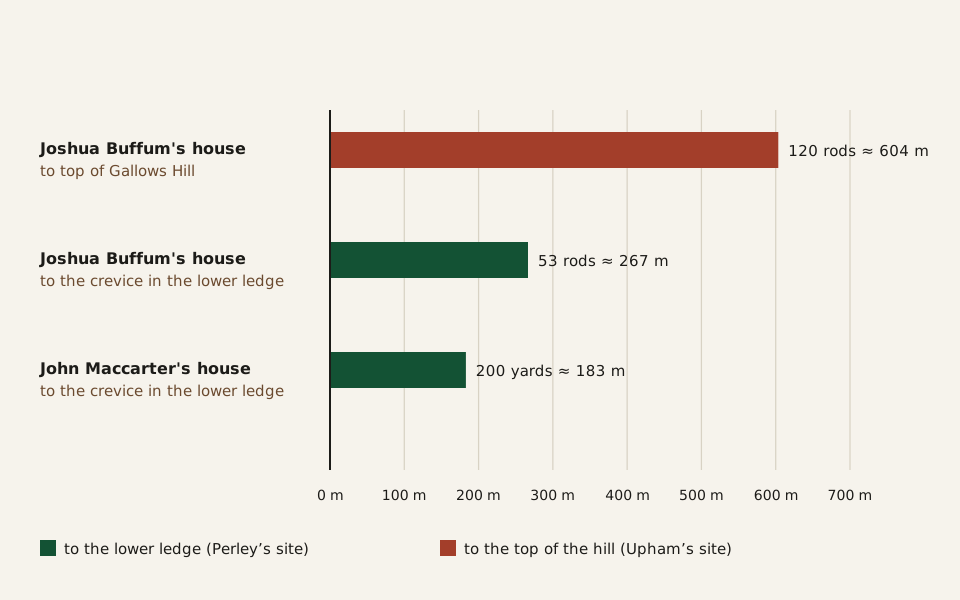
Diagram: Hoax and Hindsight · CC BY 4.0
Credit line to copy
"Perley's distances from Boston Street houses, 1921" by Hoax and Hindsight, licensed under CC BY 4.0 (https://creativecommons.org/licenses/by/4.0/). Original: https://hoaxandhindsight.com/archaeology-retested/proctors-ledge/
Data: Sidney Perley, 'Where the Salem "Witches" Were Hanged,' Essex Institute Historical Collections 57 (1921), pp. 14-16; converted at 16.5 feet to the rod, 3 feet to the yard, 0.3048 m to the foot
Perley's distances, as he gave them in 1921, converted at 16.5 feet to the rod and 3 feet to the yard. Drawn from the table published with this page (Exhibit F, pp. 15–16).
Perley's distances, with conversions (CSV) (where the data comes from) Data: Sidney Perley, Essex Institute Historical Collections 57 (1921)
Family memory filled in the rest. Perley heard that Dr. Andrew Nichols, in 1849, had pointed at large trees on that lot and told his son it was where the witches were hung. The landowner's family said they felled two big trees there about 1860, one growing from a crevice in the rock. They gave Perley a small piece of one trunk; the great fire of 1914 later destroyed the house, the shed and the remaining sections (Exhibit F, pp. 12–13).
Perley rejected the idea of a built gallows, too: “The executions must have been upon the limbs of trees.” His reason was that no town or county record showed lumber or labor paid for one. The 1692 record is not so clear. Thomas Brattle, writing on October 8, 1692, described two of the condemned behaving well “from the Goal to the Gallows, and whilst at the Gallows” (Exhibit C).
What did a prisoner see on August 19, 1692?
Perley's case rested on deeds and memories. A line in the court papers, printed in 1864, gives it a witness from the day itself (Exhibit A).
Rebecca Eames of Boxford was charged with afflicting Timothy Swan by witchcraft. She was examined before the Salem magistrates on August 19, 1692, the same day five people were hanged (Exhibit D). Near the end of the record, she was asked if she was “at ye execution.” She said she was “at ye hous below ye hill” and saw a few people there.
Look at what the answer leaves out. It names no house and no hill, and the record does not say which execution was meant. It is also a clerk's summary of a prisoner's answers, most of them admissions, not a survey.
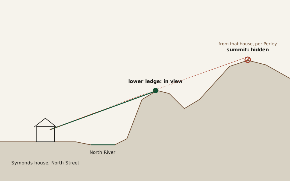
Diagram: Hoax and Hindsight · CC BY 4.0
Credit line to copy
"Line of sight from the Symonds house, schematic (not to scale)" by Hoax and Hindsight, licensed under CC BY 4.0 (https://creativecommons.org/licenses/by/4.0/). Original: https://hoaxandhindsight.com/archaeology-retested/proctors-ledge/
Data: Sidney Perley, 'Where the Salem "Witches" Were Hanged,' Essex Institute Historical Collections 57 (1921), pp. 8 and 16 (the views he describes; heights and distances not measured)
A schematic, not drawn to scale: Perley wrote that from the Symonds family house on North Street one looked over the river to the lower ledge, while the top of Gallows Hill could not be seen from it. Drawn for this page after Perley (Exhibit F, pp. 8 and 16).
Even so, the phrase fits Perley's ledge better than Upham's summit. The houses along Boston Street sat below the lower slope. According to Benjamin Ray, a member of the later research team, the local historian Marilynne Roach found the line in the court records and connected it to Perley's case (Exhibit H).
Perley singled out one of them, built about 1685 by John Maccarter, a dyer, about two hundred yards from the crevice (Exhibit F, p. 16). Maccarter sold it on November 12, 1692, for what Perley judged a price far below its worth, and Perley wondered, without proof, whether the hangings in view of its windows had something to do with it.
A site that rests on later testimony rather than a record made at the spot has a parallel in the Kensington Runestone, whose find story also comes down to what people said afterward.
What did the 2016 team add?
On January 12, 2016, Salem State University announced that two of its professors, the historian Emerson (Tad) Baker and the geologist Peter Sablock, had worked with the Gallows Hill Project to confirm Proctor's Ledge as the execution site (Exhibit G). The team's full report was not available to read for this page.
Ray's account in the University of Virginia's Salem archive fills in the method (Exhibit H). He writes that the team formed in 2010. By his account, a mapping specialist modeled what could be seen from the Boston Street houses, and with today's trees left out, the front of the ledge was in view while the summit was not. He also writes that the name Proctor's Ledge comes from its eighteenth-century owner, Thorndike Proctor, and that the City of Salem bought two small plots there in 1936 for a memorial that was never built.
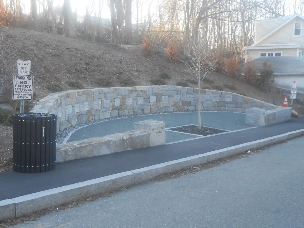
"Proctor's Ledge Memorial" by Jangseung92 — https://commons.wikimedia.org/wiki/File:Proctor's_Ledge_Memorial.jpg — CC BY-SA 4.0 (https://creativecommons.org/licenses/by-sa/4.0/)
The Proctor's Ledge memorial below the slope, photographed in May 2018. According to Ray, the City of Salem dedicated it on July 19, 2017, 325 years after the hangings of July 19, 1692.
The new work tested Perley rather than replacing him. His case had been land records and family memory; by Ray's account, the team brought in the Eames line, a line-of-sight model and a ground survey. None of it is a document from 1692 that names the spot.
Why are there no graves at the ledge?
Calef's account of August 19 explains why a grave would be hard to find. After George Burroughs was hanged, Calef wrote, “he was dragged by the Halter to a Hole, or Grave, between the Rocks, about two foot deep,” and put in with John Willard and Martha Carrier (Exhibit B). Calef adds that a hand, a chin and a foot were left uncovered.
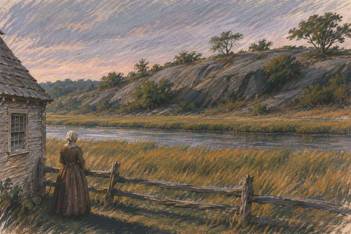
Illustration: Hoax and Hindsight. Generated schematic illustration — not a photograph or historical record. © Hoax and Hindsight, all rights reserved.
An illustration, not a record: a yard across the river from a low ledge, the kind of view Perley described from houses on North Street, with the ledge in sight and no hilltop beyond. No drawing or record from 1692 shows the place of the hangings.
Perley recorded a Buffum family tradition that Joshua Buffum, who lived on Boston Street, helped relatives carry bodies down to the river and home by boat (Exhibit F, p. 14). The same tradition held that Buffum saw the uncovered hand and foot from his house and went out after dark to cover them.
The hilltop, Perley pointed out, lay about 120 rods from that house, more than a third of a mile, while the crevice was about 53 rods away in open view (Exhibit F, p. 15). That is a family story printed more than two centuries later, not a record. The crevice the landowner's family pointed out had been emptied of its soil for their garden about 1860.
Ray writes that the team's survey used ground-penetrating radar and found crevices under the surface, but that the team chose not to excavate them. So the ledge has the same limit as any reading of ground without digging, which the page on reading layers of ground treats in general: a survey shows where soil and rock lie, not what happened there.
Popular version vs. the record
Each popular claim below is the charge; the record follows it. The test follows this site's retrial method.
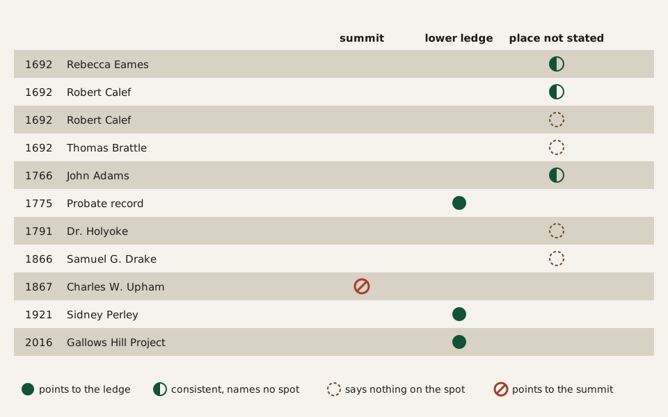
Diagram: Hoax and Hindsight · CC BY 4.0
Credit line to copy
"What each source says about the place of the 1692 hangings" by Hoax and Hindsight, licensed under CC BY 4.0 (https://creativecommons.org/licenses/by/4.0/). Original: https://hoaxandhindsight.com/archaeology-retested/proctors-ledge/
Data: W. Elliot Woodward, Records of Salem Witchcraft, vol. 2 (1864); Robert Calef, More Wonders of the Invisible World (1700), ed. Samuel G. Drake (1866), vol. 3; George Lincoln Burr, ed., Narratives of the Witchcraft Cases (1914), p. 177; Charles W. Upham, Salem Witchcraft (1867), vol. 2; Sidney Perley, Essex Institute Historical Collections 57 (1921); Salem State University news release, January 12, 2016
What each source read for this page says about the place of the 1692 hangings, one row per source, from Rebecca Eames's answer of 1692 to the 2016 announcement. Drawn from the table published with this page.
The evidence for the execution site, one row per source (CSV) (where the data comes from) Data: Woodward (1864); Calef (1700), ed. Drake (1866); Burr (1914); Upham (1867); Perley (1921); Salem State University (2016)
“At the top of this cliff, on the southern brow of the eminence, the executions are supposed to have taken place.” Upham, Salem Witchcraft (1867), vol. 2, p. 378.
No 1692 paper read here names the spot, and Upham wrote that no contemporary record did. Eames said in 1692 that she was at the house below the hill; Perley in 1921 traced the site to the lower ledge. (Exhibits A, E, F)
The hilltop tradition “has been uniform and continuous.” Upham (1867), vol. 2, p. 377.
Perley wrote in 1921 that he found no tradition, record or other evidence placing the executions on top. The traditions he gathered point to the locust-tree lot on the lower ledge. (Exhibit F, pp. 9 and 12–16)
“The Hill” has been pointed out as Gallows Hill ever since. Drake's note in his 1866 edition of Calef, vol. 3, p. 45.
This one fits the record on the place: Proctor's Ledge is on the lower slope of the same hill. The records read here do not show the name in use from 1692 on: Adams wrote of Witchcraft hill in 1766, and the earliest mention of Gallows Hill pasture that Perley found was in 1789. (Exhibits B, F)
Where were the Salem witches hanged?
By current evidence, at Proctor's Ledge, a ledge on the lower slope of Gallows Hill above Boston Street in Salem, not on the summit. Sidney Perley argued this from land records and family traditions in 1921, and the Gallows Hill Project confirmed it in 2016. No 1692 document read for this page names the spot, and no archaeological excavation has been reported there.
Is Proctor's Ledge on Gallows Hill?
Yes. Proctor's Ledge is part of the same hill, on its lower slope. The difference is between the summit, where Charles Upham placed the hangings in 1867, and the ledge below it, where Sidney Perley placed them in 1921.
Were the victims buried at Proctor's Ledge?
Some may have been, for a time. Robert Calef wrote that George Burroughs, John Willard and Martha Carrier were put in a shallow hole between the rocks after the hanging of August 19, 1692. Family traditions printed by Perley say relatives took other bodies away. No archaeological excavation at the ledge has been reported.
Why did it take until 2016 to confirm?
Perley made the case in 1921, but it rested on deeds and family memory. According to Benjamin Ray, a member of the team, it brought in a line from Rebecca Eames's 1692 examination, a line-of-sight model and a ground survey before the site was announced as confirmed.
What would overturn it:
- A document from 1692 or 1693, such as a sheriff's account or a county expense record, naming the place of execution as somewhere other than the lower ledge.
- A dated archaeological find of 1692 execution or burial evidence somewhere on Gallows Hill other than the ledge, published with its excavation record.
Exhibits
Records and period publications
- Exhibit A: W. Elliot Woodward, ed., Records of Salem Witchcraft, Copied from the Original Documents, vol. 2 (Roxbury, Mass., 1864), pp. 142–146: indictments of Rebecca Eames and her examination before the Salem magistrates, August 19, 1692.
- Exhibit B: Robert Calef, More Wonders of the Invisible World (London, 1700), in Samuel G. Drake, ed., The Witchcraft Delusion in New England, vol. 3 (Roxbury, Mass., 1866), with Drake's notes and appendix.
- Exhibit C: Thomas Brattle, letter of October 8, 1692, in George Lincoln Burr, ed., Narratives of the Witchcraft Cases, 1648–1706 (New York: Charles Scribner's Sons, 1914), pp. 169–190.
- Exhibit D: Diary of Samuel Sewall, 1674–1729, vol. 1, Collections of the Massachusetts Historical Society, 5th series, vol. 5 (Boston, 1878).
Studies
- Exhibit E: Charles W. Upham, Salem Witchcraft, 2 vols. (Boston, 1867).
- Exhibit F: Sidney Perley, 'Where the Salem “Witches” Were Hanged,' Historical Collections of the Essex Institute 57, no. 1 (January 1921): 1–18.
- Exhibit G: Salem State University, 'History Prof. Tad Baker and Geology Prof. Peter Sablock Help Confirm Salem Witch Site,' news release, January 12, 2016.
- Exhibit H: Benjamin C. Ray, 'The Gallows Hill Project: Confirming the Location of the 1692 Salem Execution Site,' Salem Witch Trials Documentary Archive and Transcription Project, University of Virginia.
Cite this page
Hoax and Hindsight. “Proctor’s Ledge: Perley Put Salem’s Hangings There in 1921.” Hoax and Hindsight, published November 6, 2026. https://hoaxandhindsight.com/archaeology-retested/proctors-ledge/. Accessed [the date you read it].
Related cases
Stratigraphy: The Deepest Layer in a Dig Isn’t Always Oldest
Stratigraphy reads the order of layers: lower is earlier, unless a later pit, burrow or collapse cuts through. It gives a sequence, not a calendar date.
Picture credit
"Archaeological excavation (חפירה ארכיאולוגית), Israel, August 1957" by Benno Rothenberg / Meitar Collection / National Library of Israel / The Pritzker Family National Photography Collection — https://commons.wikimedia.org/wiki/File:Archaeological_excavations_(997009157511605171.jpg — CC BY 4.0 (https://creativecommons.org/licenses/by/4.0/); modified: card and share image cropped to 16:10 by the site build; the article page shows the full frame
Terminus Post Quem: Newest Original Part Sets a Date Floor
A terminus post quem is the earliest date a layer or object can have, set by its newest dated part. It gives a floor, not a date; the ante quem sets a ceiling.
Picture credit
"Cranborne chase stater (PAS FindID 983439)" by The Portable Antiquities Scheme — https://commons.wikimedia.org/wiki/File:Cranborne_chase_stater_(FindID_983439).jpg — CC BY 2.0 (https://creativecommons.org/licenses/by/2.0/); modified: card and share image cropped to 16:10 by the site build; the article page shows the full frame
 Illustration
Kensington Runestone: Its 1910 Panel’s Own Expert Said No
In 1910 a Minnesota panel backed the Kensington Runestone on one condition; its specialist rejected it. By current evidence it is not accepted as medieval.
Picture credit
Illustration: Hoax and Hindsight. Generated schematic illustration — not a photograph or historical record. © Hoax and Hindsight, all rights reserved.