Historical Hoaxes · Case retrial
Vinland Map: Yale Found a Pigment First Sold in the 1920s
Hoax and Hindsight Published
Yale University’s library now says the Vinland Map in its own collection is a forgery. In 2021, Yale’s conservators and scientists reported that a titanium pigment that went on sale in the 1920s runs through the map’s lines and text, so the medieval date of its parchment no longer decides the case.
Docket
- Case
- The Vinland Map
- Years
- Made public by Yale in 1965; declared a forgery by Yale in 2021
- Place
- Beinecke Rare Book & Manuscript Library, Yale University
- The claim
- That it is a 15th-century map showing Vinland, part of North America’s coast southwest of Greenland, drawn before Columbus
- The verdict
- Finding of the 2021 Yale re-examination: a forgery; a titanium pigment that went on sale in the 1920s runs through the map’s lines and text
- Hinges on
- What is in the ink, not how old the parchment is
- Status
- Exposed
The Vinland Map is a sheet of parchment, 27.8 by 41.0 centimetres, kept at Yale’s Beinecke Rare Book & Manuscript Library (Exhibits A, G). It purports to be a 15th-century map, and it shows an island labelled Vinlanda Insula, part of North America’s coast southwest of Greenland.
Yale made the map public on October 11, 1965, according to the map historian Helen Wallis (Exhibit E). On September 1, 2021, Yale announced that it was a fake (Exhibit A). Between those dates lie nearly 56 years and a long series of tests that pointed in different directions. This page reopens the file and calls the main tests and readings in the order they were made.
Order of proceedings 6 parts
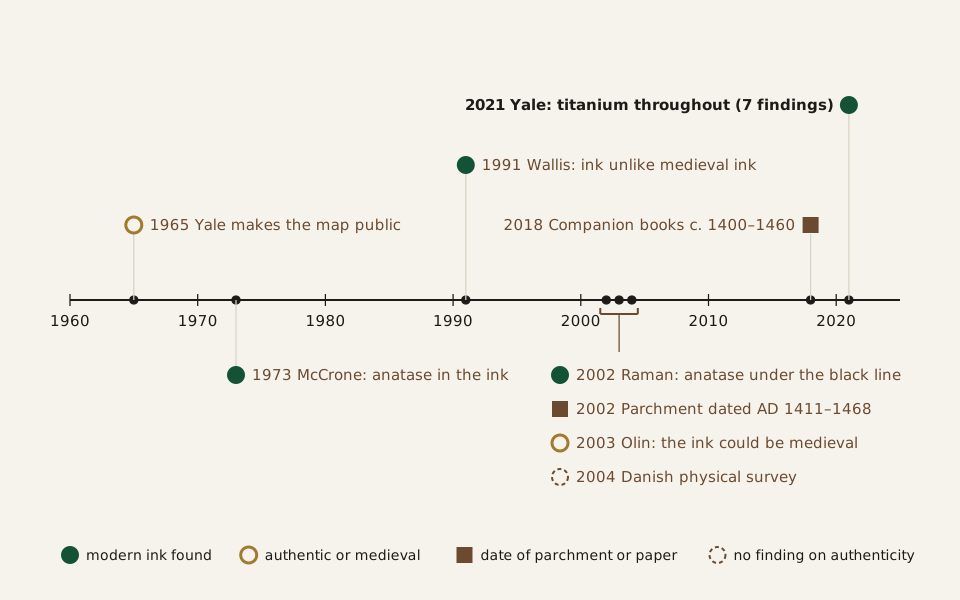
Diagram: Hoax and Hindsight · CC BY 4.0
Credit line to copy
"Tests and published readings of the Vinland Map, 1965 to 2021" by Hoax and Hindsight, licensed under CC BY 4.0 (https://creativecommons.org/licenses/by/4.0/). Original: https://hoaxandhindsight.com/proven-fakes/vinland-map/
Data: Yale News (September 1, 2021); published abstracts and bibliographic records of the Vinland Map studies of 1966–2004 listed in the Exhibits
Every test and published reading in this page’s table, 1965 to 2021. Filled circles mark findings of modern ink; outlined circles mark readings that the map is authentic or medieval; squares mark dates of the parchment or paper. Drawn from the table published with this page (Exhibit A and Exhibits C to L).
The tests and readings, one row per finding, with sources (CSV) (where the data comes from) Data: Yale News (September 1, 2021); published abstracts of the Vinland Map studies of 1966–2004 listed in the Exhibits
What did Yale announce in 1965?
In 1965 Yale presented the map with a scholarly book, The Vinland Map and the Tartar Relation, by R. A. Skelton, Thomas E. Marston and George D. Painter (Exhibit B). Yale News recalled in 2021 that the announcement caused a sensation and seemed to show that Norse sailors had reached the New World before any other Europeans (Exhibit A). The book’s authors argued firmly for the map and linked it to the Council of Basel, a church council that met from 1431 to 1449 (Exhibit G).
The map did not arrive alone. When it reached Yale, it was bound inside a slim manuscript called the Tartar Relation, an account of a 13th-century journey to the Mongol lands, in a modern binding (Exhibit A). Yale later acquired a third item, part of a medieval encyclopedia called the Speculum Historiale. Yale’s copy of that volume is dated to the time of the Council of Basel.
“Detail of a page of the Speculum Historiale, Beinecke Library” · Unknown author · Public domain
Full credit
"Detail of a page of the Speculum Historiale, Beinecke Library" by Unknown author — https://commons.wikimedia.org/wiki/File:Beinecke-speculum-hist-223r-det.jpg — Public domain (manuscript written about 1440 by an anonymous scribe: public domain in the US (published or not, created far more than 120 years ago) and in the EU (anonymous work, term long expired); the image is a faithful photographic reproduction of a two-dimensional public-domain work, which adds no new copyright in the US (PD-Art) or in the EU (Directive (EU) 2019/790, Art. 14); marked Public Domain Mark 1.0 on Commons)
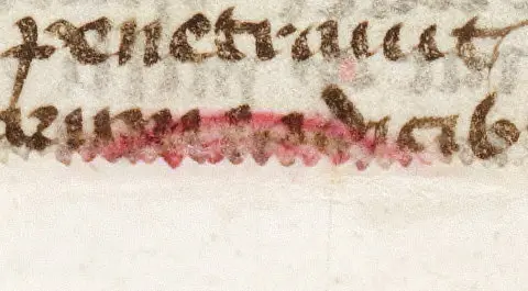
A small detail from Yale’s copy of the Speculum Historiale, written around 1440. This genuine medieval volume is the likely source of the map’s parchment, by Yale’s 2021 account (Exhibit A).
Doubts came early. Writing in the Journal of Navigation in 1966, M. W. Richey noted that an antiquarian bookseller in New Haven, Connecticut, had found the map, and that the circumstances had so far blocked a proper look at its history (Exhibit C). In other words, its provenance, the record of who owned it and when, was missing. Richey also called the date of about 1450 provisional, and added that a genuine map would be the earliest surviving map of any part of the Americas.
From then on, Wallis wrote in 1991, specialists argued over the map in many publications and conferences (Exhibit E). This site retries the same pattern, acceptance by well-known names and the long argument that follows it, in the Cottingley fairy photographs.
What did the ink tests find before 2021?
The first decisive-looking result came from the ink. A 1973 study by McCrone Associates found anatase in it, a titanium dioxide that did not enter commercial use until the 1920s (Exhibit A). Walter and Lucy McCrone published the finding in The Geographical Journal in 1974 (Exhibit D). Those tests sampled specific points, not the whole map.
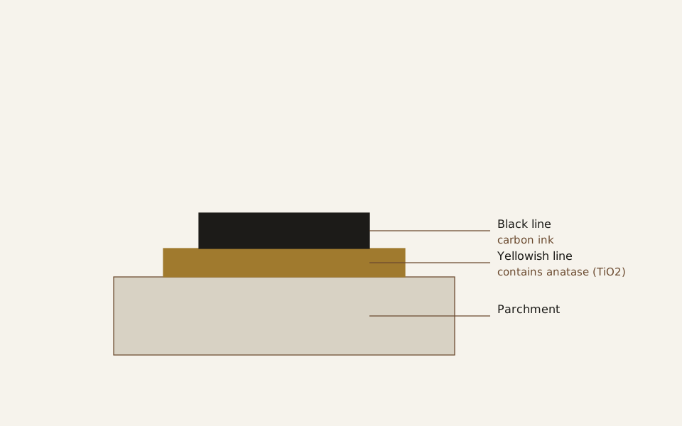
Diagram: Hoax and Hindsight · CC BY 4.0
Credit line to copy
"Layers in a line of the Vinland Map ink, as described in 2002" by Hoax and Hindsight, licensed under CC BY 4.0 (https://creativecommons.org/licenses/by/4.0/). Original: https://hoaxandhindsight.com/proven-fakes/vinland-map/
Data: Katherine L. Brown and Robin J. H. Clark, Analytical Chemistry 74 (2002), abstract
How Brown and Clark described the map’s drawn lines in 2002: black carbon ink lying on a yellowish line that contains anatase. A schematic, not a picture of the map (Exhibit F).
Later work kept pointing the same way. In 1991 Helen Wallis, a former head of maps at the British Library, summed up the analyses made in Europe and the United States since 1968: the ink resembled no known medieval ink, and the map appeared to be a fake, though she called for more study (Exhibit E, in French). Not every analysis is retold here. A 1987 study of the inks and parchment by T. A. Cahill and colleagues, and a 1988 paper by Walter McCrone, were read only as bibliographic entries (Exhibits O, P).
In 2002 the chemists Katherine L. Brown and Robin J. H. Clark used Raman microprobe spectroscopy, which reads a material’s chemistry from scattered laser light. They found that the black ink of each feature lies over a yellow line containing anatase, a layer they did not find elsewhere on the map (Exhibit F). A modern, post-1923 origin, they wrote, was strongly indicated.
The case was not closed. In 2003 Jacqueline S. Olin published “Evidence that the Vinland Map is medieval” in Analytical Chemistry (Exhibit I). She argued that carbon was sometimes added to medieval inks, and that anatase could come from the way medieval inks were made. Replies came in the same journal in 2004, including Kenneth M. Towe’s “The Vinland Map Ink Is NOT Medieval” and a rebuttal from Clark (Exhibits J, K).
One more study looked at the whole sheet before Yale’s. In 2004 Danish scientists measured the map’s colour, thickness, flexibility and transparency, and assessed damage to its parchment (Exhibit A). Yale News reports no finding on authenticity from that work.
| Year | Who | Method | What it found |
|---|---|---|---|
| 1973 | McCrone Associates | Ink samples | Anatase, first sold in the 1920s |
| 1991 | Helen Wallis | Review of tests since 1968 | Ink unlike any known medieval ink |
| 2002 | Brown and Clark | Raman spectroscopy | Black carbon line over a yellow line with anatase |
| 2002 | Donahue, Olin and Harbottle | Radiocarbon | Parchment AD 1411–1468 (95 percent) |
| 2003 | Jacqueline Olin | Argument from medieval ink making | Ink could be medieval |
| 2004 | Danish scientists | Colour, thickness, flexibility | No finding on authenticity reported |
| 2018 | Yale | Radiocarbon | Companion books c. 1400–1460 |
| 2021 | Yale | Macro-XRF, Raman, FE-SEM | Titanium throughout; pigment like one made in 1923 |
How old is the parchment?
The parchment is old, and nobody in this record disputes that. In 2002, D. J. Donahue, J. S. Olin and G. Harbottle dated it by radiocarbon to AD 1434, plus or minus 11 years (Exhibit G). At 95 percent confidence the range is AD 1411 to 1468.
In a comment in the same journal, K. R. Ludwig argued that the separate measurements scattered more than the stated error allowed (Exhibit H). His point was about the size of the error margin, not the century.
Yale’s own radiocarbon tests in 2018 dated the parchment and paper of the two companion manuscripts to about 1400 to 1460 (Exhibit A). A watermark in the Speculum Historiale traces to a paper mill that worked in Basel in the 1440s. The text of both manuscripts is written in a similar hand, likely by the same scribe. The parchment, the paper and the handwriting all fit the mid-1400s.
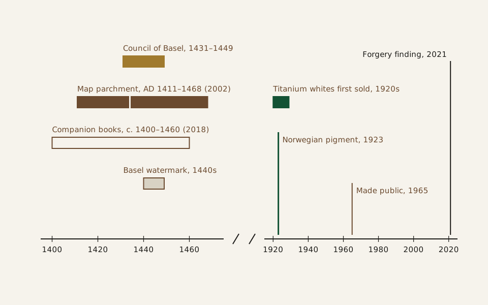
Diagram: Hoax and Hindsight · CC BY 4.0
Credit line to copy
"Parchment dates of the 1400s set against a pigment of the 1920s" by Hoax and Hindsight, licensed under CC BY 4.0 (https://creativecommons.org/licenses/by/4.0/). Original: https://hoaxandhindsight.com/proven-fakes/vinland-map/
Data: D. J. Donahue, J. S. Olin and G. Harbottle, Radiocarbon 44 (2002), abstract; Yale News (September 1, 2021)
Two stretches of time, with the gap between 1475 and 1915 cut out. Left: the dates of the parchment, the companion books and the Basel watermark. Right: titanium white pigments of the 1920s, the 1923 Norwegian pigment, and the map’s modern history (Exhibits A, G).
But a radiocarbon date belongs to the skin, not to what was later drawn on it. An old blank sheet can carry new ink.
The ink sets the earliest date the drawing could have been made, a limit known as a terminus post quem: an object can be no older than its newest ingredient. If the drawn lines hold a pigment first made in the 1920s, the drawing dates from the 1920s or later. The parchment’s central date, 1434, is 489 years older than the 1923 pigment that the map’s anatase was later found to resemble.
What did Yale find in 2021?
Yale’s 2021 team paired two Yale University Library conservators with scientists from Yale’s Institute for the Preservation of Cultural Heritage (Exhibit A). Unlike earlier testers, they had open access to the map and both companion manuscripts for as long as they needed. Their main tool was macro X-ray fluorescence, or macro-XRF, which maps the chemical elements across a whole flat object.
The conservators were Marie-France Lemay and Paula Zyats. The scientists included Anikó Bezur, Richard Hark and Pablo Londero (Exhibit A). X-ray fluorescence had been used on single points for decades. Only recently, Bezur said, had it become possible to scan a whole flat object this way in a laboratory.
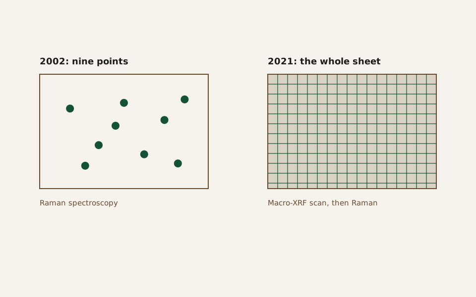
Diagram: Hoax and Hindsight · CC BY 4.0
Credit line to copy
"Where the ink was tested: nine points in 2002, the whole sheet in 2021" by Hoax and Hindsight, licensed under CC BY 4.0 (https://creativecommons.org/licenses/by/4.0/). Original: https://hoaxandhindsight.com/proven-fakes/vinland-map/
Data: Yale News (September 1, 2021); D. J. Donahue, J. S. Olin and G. Harbottle, Radiocarbon 44 (2002), abstract
Where the ink was tested: nine points in the 2002 Raman study, and the whole sheet in Yale’s 2021 scan. Blank sheets in the map’s proportions; no map is drawn, and the point positions are schematic (Exhibits A, G).
The scan found titanium throughout the map’s lines and text. Look at what it did not find: little or no iron, sulfur or copper, the elements expected in iron gall ink, the usual ink of medieval scribes. Over the Vinlanda Insula coastline, the scan showed high titanium with smaller amounts of barium. Titanium white, as first sold commercially in the 1920s, mixed titanium dioxide with barium sulfate.
Three more steps bear on the objection raised in 2003. Raman microscopy showed the titanium in the ink is anatase, spread broadly over the sheet rather than at a few points. The inks of 50 manuscript fragments made in Central Europe in the 15th century held far less titanium and much more iron than the map. Under an electron microscope, the map’s anatase particles closely resembled a pigment made commercially in Norway in 1923, and nothing suggested a natural source.
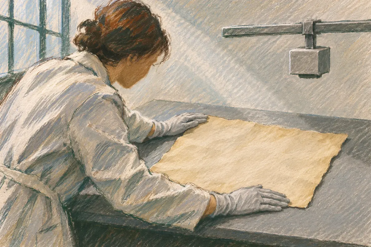
Illustration: Hoax and Hindsight. Generated schematic illustration — not a photograph or historical record. © Hoax and Hindsight, all rights reserved.
An illustration of an imagined scene of the kind of work behind Yale’s 2021 re-examination: a conservator lays a parchment sheet flat for a scan of the whole sheet. Not a picture of the Vinland Map or of Yale’s laboratory.
“The Vinland Map is a fake,” said Raymond Clemens, Yale’s curator of early books and manuscripts (Exhibit A). This page follows Yale’s 2021 finding because it is the only ink analysis that covered the whole sheet, compared the map with 15th-century inks, and found the pigment closely resembled a dated modern product. The earlier point tests from 1973 and 2002 are consistent with it; Olin’s 2003 argument is the reading it answers.
The record of 2021 has limits of its own. It comes from Yale News, the university’s news office, reporting on work done in Yale’s own laboratories on an object in Yale’s own library. The team said it planned to publish the details in scholarly articles, and this page has not read a technical report. The findings above are given as Yale described them.
Was it made to deceive, and who made it?
Modern ink was not all Yale’s team found. On the back of the map was a short Latin note in iron gall ink, possibly a bookbinder’s note about where a section of the Speculum Historiale belonged (Exhibit A). Someone had written over it in titanium-containing ink, so that it read like an instruction to bind a drawing into the medieval volume. Infrared light also showed altered text in the Tartar Relation, and the altered text is in modern ink.
The Speculum Historiale is a large work of 32 sections, usually bound in four volumes. Yale’s copy holds books 21 to 24, the second half of the third volume, and the original note fits that copy (Exhibit A). A 14th-century copy of the complete work found in Lucerne, Switzerland, has a Tartar Relation bound into its last volume, so the two texts had been bound together before.
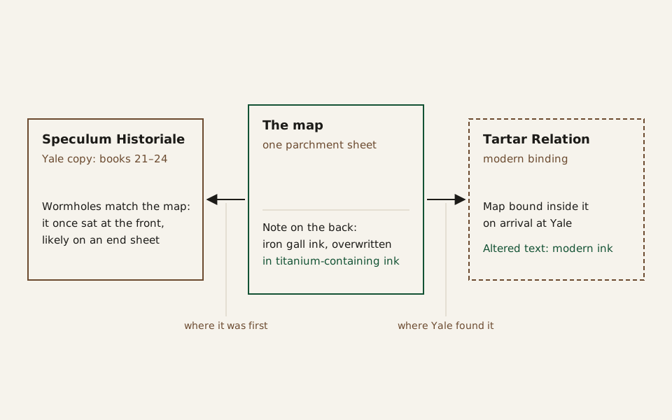
Diagram: Hoax and Hindsight · CC BY 4.0
Credit line to copy
"How the Vinland Map, the Speculum Historiale and the Tartar Relation fit together" by Hoax and Hindsight, licensed under CC BY 4.0 (https://creativecommons.org/licenses/by/4.0/). Original: https://hoaxandhindsight.com/proven-fakes/vinland-map/
Data: Yale News (September 1, 2021)
How the three items fit together, by Yale’s 2021 account: matching wormholes place the map at the front of the Speculum Historiale, likely on an end sheet; it reached Yale inside the Tartar Relation. A diagram, not a picture of the objects (Exhibit A).
The team’s scientists read the altered note as evidence of a motive to deceive. By Clemens’s account, it shows a forgery rather than an innocent drawing later passed off by someone else, but it does not say who made it.
Yale’s 2021 announcement names no maker. This page treats the maker as unknown. A 2006 article by P. D. A. Harvey in Imago Mundi, titled “The Vinland Map, R. A. Skelton and Josef Fischer” (Exhibit M), was read here only as a bibliographic entry, and its argument is not reported. The same question, what is in the paint and when could it have been made, comes up in the case of Han van Meegeren’s paintings.
Popular version vs. the record
Each popular claim below is the charge, with the record set after it. The test, as on every page here, is the one set out in the retrial method: the claim must come from a named publication, and the record comes last.
The map proved the Norse reached America before Columbus. Yale News recalled in 2021 that the 1965 find seemed to show this (Exhibit A). In 1966 Richey reported publicity for it in outlets “ranging from learned journals to glossies,” and called it, if authentic, the earliest surviving map of any part of the Americas (Exhibit C).
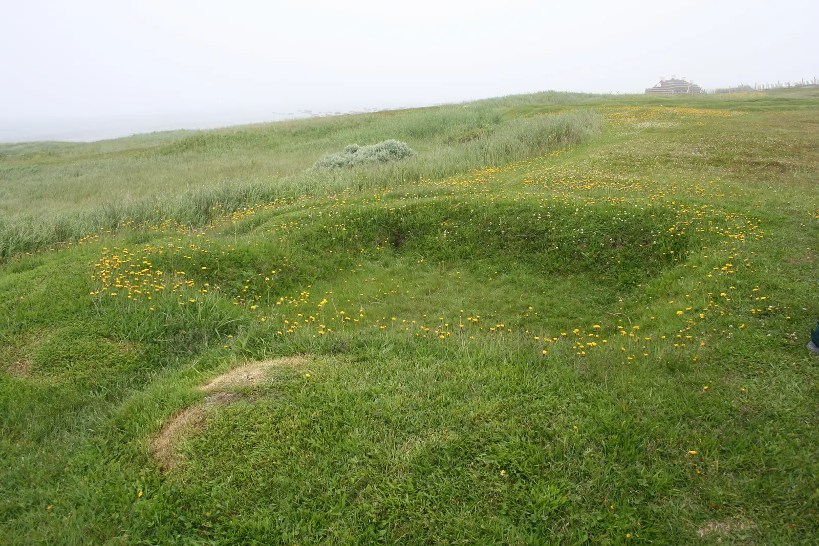
The Norse did reach North America, but the proof is in the ground. Digs at L’Anse aux Meadows in Newfoundland in the 1960s confirmed a Norse settlement, and a 2022 study dated a Norse presence in Newfoundland to AD 1021. Yale’s 2021 tests make the map a 20th-century drawing, so it adds nothing to that case. (Exhibits A, N)
The parchment is medieval, and the ink could be medieval too. Olin wrote in 2003 that radiocarbon had confirmed a 15th-century parchment, and argued that the carbon and anatase in the ink could come from the way medieval inks were made (Exhibit I).
The first half matches the record. A 2002 radiocarbon study dated the parchment to AD 1411 to 1468 at 95 percent, and a comment that year questioned its error margin, not its century. The ink is a separate question, and Yale found a 1920s-type titanium pigment throughout the drawn lines in 2021. (Exhibits A, G, H)
Science proved it modern in the 1970s. Writing in 2004, Michael Henchman said: “Twenty-nine years ago, the Vinland Map was shown incontrovertibly to be modern” (Exhibit L).
This one partly matches the record. The 1973 finding of anatase pointed the same way as Yale’s, but it covered points, not the whole sheet, and it was still disputed in print in 2003. Yale’s own forgery finding came in 2021. (Exhibits A, D, I)
"L'Anse aux Meadows, mounds from original Viking Longhouse" by Acunsolo — https://commons.wikimedia.org/wiki/File:L%27Anse_aux_Meadows,_mounds_from_original_Viking_Longhouse.JPG — CC BY-SA 3.0 (https://creativecommons.org/licenses/by-sa/3.0/)
The low mounds of an original Norse longhouse at L’Anse aux Meadows, Newfoundland, photographed in 2009. The evidence that the Norse reached North America comes from sites like this one, not from the map (Exhibits A, N).
Is the Vinland Map real?
No, by Yale’s 2021 finding. Its parchment dates to the 1400s, but a titanium pigment first sold in the 1920s runs through its lines and text, and a note on its back was overwritten in the same kind of modern ink. Earlier ink tests from 1973 and 2002 pointed the same way. A 2003 argument that the ink could be medieval was met, in this page’s reading, by the 2021 tests, which compared the map with 15th-century inks.
How old is the Vinland Map?
The parchment dates to AD 1411–1468 at 95 percent confidence, by a 2002 radiocarbon study. The drawing is younger: its ink holds a pigment first sold in the 1920s, so it was drawn in the 1920s or later. The map was made public by Yale in 1965.
Who made the Vinland Map?
No test has identified the maker. Yale’s 2021 announcement reported evidence that the forgery was deliberate but did not name anyone.
Did the Norse reach America before Columbus?
Yes, but the evidence is archaeological, not the map. Excavations at L’Anse aux Meadows in Newfoundland in the 1960s confirmed a Norse settlement, and a 2022 study dated a Norse presence in Newfoundland to AD 1021. That study fixed the date using a known spike in atmospheric radiocarbon caused by cosmic rays in AD 993. Another object offered as evidence of Norse travel in North America is retried on the page on the Kensington Runestone.
Where is the Vinland Map now?
At Yale’s Beinecke Rare Book & Manuscript Library, with the Speculum Historiale and the Tartar Relation. Yale said in 2021 that it would stay there as a historical object in its own right.
What would overturn it:
- A dated record from before the 1920s showing the map’s drawn lines. A photograph, description or sale record from before titanium white pigments were sold, independently dated and showing the Vinlanda Insula coastline on this sheet, would contradict the pigment date.
- Repeated ink analyses outside Yale that place the titanium on the surface only. If other laboratories found that the anatase sits in surface dirt or a later coating, and not in the ink lines themselves, this page’s verdict would have to be reopened.
Exhibits
Records and period publications
- Exhibit A: Mike Cummings, “Analysis unlocks secret of the Vinland Map — it’s a fake,” Yale News, September 1, 2021.
Studies
- Exhibit B: G. R. Crone, “The Vinland Map Cartographically Considered,” review of R. A. Skelton, Thomas E. Marston and George D. Painter, The Vinland Map and the Tartar Relation (1965), The Geographical Journal 132 (1966): 75.
- Exhibit C: M. W. Richey, “The Vinland Map,” Journal of Navigation (January 1966).
- Exhibit D: Walter C. McCrone and Lucy B. McCrone, “The Vinland Map Ink,” The Geographical Journal 140 (1974): 212.
- Exhibit E: Helen Wallis, “The Vinland Map: Genuine or Fake?” Bulletin du bibliophile (1991).
- Exhibit F: Katherine L. Brown and Robin J. H. Clark, “Analysis of pigmentary materials on the Vinland Map and Tartar Relation by Raman microprobe spectroscopy,” Analytical Chemistry 74 (2002): 3658–3661.
- Exhibit G: D. J. Donahue, J. S. Olin and G. Harbottle, “Determination of the Radiocarbon Age of Parchment of the Vinland Map,” Radiocarbon 44 (2002): 45–52.
- Exhibit H: K. R. Ludwig, “Comment on ‘Determination of the Radiocarbon Age of Parchment of the Vinland Map’,” Radiocarbon 44 (2002): 597–598.
- Exhibit I: Jacqueline S. Olin, “Evidence that the Vinland Map is medieval,” Analytical Chemistry 75 (2003): 6745–6747.
- Exhibit J: Kenneth M. Towe, “The Vinland Map Ink Is NOT Medieval,” Analytical Chemistry 76 (2004): 863–865.
- Exhibit K: Robin J. H. Clark, “The Vinland Map - still a 20th century forgery,” Analytical Chemistry 76 (2004): 2423.
- Exhibit L: Michael Henchman, “On the absence of evidence that the Vinland map is medieval,” Analytical Chemistry 76 (2004): 2674.
- Exhibit M: P. D. A. Harvey, “The Vinland Map, R. A. Skelton and Josef Fischer,” Imago Mundi (January 2006).
- Exhibit N: Margot Kuitems, Birgitta L. Wallace, Charles Lindsay and others, “Evidence for European presence in the Americas in AD 1021,” Nature 601 (2022): 388–391.
- Exhibit O: T. A. Cahill, R. N. Schwab, B. H. Kusko, R. A. Eldred, G. Moller, D. Dutschke, D. L. Wick and A. S. Pooley, “The Vinland map, revisited: new compositional evidence on its inks and parchment,” Analytical Chemistry 59 (1987): 829–833.
- Exhibit P: Walter C. McCrone, “The Vinland Map,” Analytical Chemistry 60 (1988): 1009–1018.
Cite this page
Hoax and Hindsight. “Vinland Map: Yale Found a Pigment First Sold in the 1920s.” Hoax and Hindsight, published November 6, 2026. https://hoaxandhindsight.com/proven-fakes/vinland-map/. Accessed [the date you read it].
Related cases
Mechanical Turk: Its Hidden Player Was Suspected in 1784
The Mechanical Turk chess automaton hid a human player. Who said so by 1784, what Willis argued in 1821, and why Napoleon’s game rests on later accounts.
Picture credit
"Plate I (Tab. I) of Joseph Friedrich zu Racknitz, Ueber den Schachspieler des Herrn von Kempelen und dessen Nachbildung (1789)" by Joseph Friedrich zu Racknitz — https://commons.wikimedia.org/wiki/File:Racknitz_-_The_Turk_1.jpg — Public domain (engraved plate published in 1789: public domain in the US (published before 1931); in the EU the term has long expired, since the book's author and any engraver working on a plate printed in 1789 died well over 70 years ago (an engraver active in 1789 cannot have lived past 1955); the scan is a faithful photographic reproduction of a two-dimensional public-domain work, which adds no new copyright in the US (PD-Art) or in the EU (Directive (EU) 2019/790, Art. 14); marked Public Domain Mark 1.0 on Commons. Commons gives the source as the Humboldt University Library (digi-hub record BV041097321, scan page 63); that record's own rights field says the copyright status was not checked, which concerns the reproduction only.)
Cottingley Fairies: Kodak Would Not Vouch, Doyle’s Book Says
Arthur Conan Doyle’s 1922 book records that Kodak’s experts found no trick in the Cottingley fairy negatives in 1920, yet would not certify them as genuine.
Picture credit
"Dancing fairies, illustration by Claude A. Shepperson in Princess Mary's Gift Book (1914)" by Claude A. Shepperson — https://commons.wikimedia.org/wiki/File:Cottingley_fairies_illustration.jpg — Public domain (US: published in London in 1914, before January 1, 1931. EU: Claude A. Shepperson died in 1921 (life dates 1867-1921 on the Commons file page and in the image-rights review of 2026-11-05), more than 70 years ago. Scan chain: the Commons file gives as its source the Internet Archive scan princessmarysgif00mary (University of California Libraries, collection cdl, not a lending item; its metadata, read 2026-11-05, gives the date [1914] and the publisher Hodder & Stoughton). Page and poem checked in review on 2026-11-06 against the same scan: the _djvu.txt text and the scan page for printed p. 104 (leaf 130 in the item's page-number file) show the drawing below the last stanzas of Alfred Noyes, 'A Spell for a Fairy' (pp. 101-104), headed 'Painting and Drawings by Claude A. Shepperson, A.R.W.S.'; the contents page lists the poem under Noyes with the same credit. The IA item metadata was re-read the same day (collection cdl and americana, possible-copyright-status NOT_IN_COPYRIGHT, not a lending item).); modified: card and share image cropped by the site build to the card proportions; the article page shows the full drawing
Anna Anderson and the Tichborne Claimant: A Jury, Then DNA
A London jury convicted the Tichborne Claimant of perjury in 1874; DNA tests published in 1995 exposed Anna Anderson, per a 2009 study. Two proofs compared.
Picture credit
"The Tichborne Trial, oil painting by Frederick Sargent (Hampshire County Council Museums Service, FA2005.237.1)" by Frederick Sargent — https://commons.wikimedia.org/wiki/File:The_Tichborne_Trial_by_Frederick_Sargent.jpg — Public domain (oil painting by Frederick Sargent (1837-1899, per the Commons creator record; not checked against another source): public domain in the EU (painter dead for more than 70 years) and in the US (author died before 1956, so even an unpublished work is out of copyright); the image is a faithful photographic reproduction of a two-dimensional public-domain work (PD-Art), which adds no new copyright in the US or in the EU (Directive (EU) 2019/790, Art. 14); marked Public Domain Mark 1.0 on Commons. Risk noted: the photograph came from Art UK for a UK collection, and a UK museum may claim rights in the reproduction; accepted in the image rights ruling of 2026-11-05 (log, image ruling 8).)